GPS Geotagging – Around the World in One Day
What is geotagging? I traveled around the world in one day
to find out for myself. When we buy a brand new camera, the first thing we
usually set is the day, month, year, and time.. This data,
embedded into each photo we take, effectively answers the question "when did this happen?" Geotagging
additionally answers the question "where
did this happen" Armed with a GPS device and a camera I set out on a field trip
to the World Showcase at Disney's EPCOT Center to find out exactly how GPS
technology works.
BRIEF OVERVIEW
Geotagging technology determines the precise location of
where a specific photo is captured.
In general, a GPS (Global Positioning System) receiver communicates with GPS
satellites to accurately determine position and location. This data is then
recorded directly onto the photo file's metadata.
Similar to reception from cell phone to tower, the GPS
receiver must be within clear shot of a GPS satellite to obtain a clear,
accurate signal. Indoor reception, therefore, is possible, but limited. The GPS
receiver for cameras actively gathers data from NAVSTAR satellites. When four
or more of these satellites are in transmission range of a GPS receiver, a
3-dimensional position or triangulation is derived. This signal, in turn,
translates into raw data—latitude, longitude and altitude co-ordinates on the
GPS receiver.
Geotagging technology with a GPS receiver allows you to
easily create a visual map of your travels. For example, when your photos are
uploaded to online photo sharing sites like Flickr and Google Earth, or to a
simple desktop application such as iPhoto, a virtual map of your travels is
"tacked" with pins. Simply click on a pin, for quick access and organization of
your photo library.
For the everyday photographer or travel writer with a photo
library numbering in the thousands, a visual photographic map provides quick,
easy access to events and locations. For professional applications such as
surveying, geotagging is an indispensable toolset for visual and numerical data
gathering.
With a few exceptions, GPS devices come in 2 basic
varieties—tethered and untethered.
A tethered GPS device connects directly to the camera via
cable. Conversely, an untethered GPS device, gathers raw GPS data, which is
later synched to the photos via software. Above all, make sure that the GPS
device you choose is compatible with your camera.
We'll shortly go into the details of tethered and untethered
units, and take you through a visual journey around the World Showcase at Epcot
Center to illustrate geotagging in action.
TETHERED GPS DEVICES
Tethered GPS units connect directly to your camera with a
supplied cable, for plug and play convenience. GPS data is gathered in
real-time—as you take the photo, the GPS coordinates are recorded directly into
the photo's EXIF metadata. Colored or blinking LED lights indicate whether or
not the unit is within the range of a GPS signal.
The device usually pulls a charge from the host camera's
battery for power. A sleep mode or power saving option is available on some
tethered units to ease the drain on your battery.
Mount the tethered unit on the camera's hot shoe or camera
strap. If you're using the camera's pop-up flash frequently, a GPS unit mounted
on the hot shoe can physically prevent the flash from firing. Alternatively,
mount the unit with supplied clips onto your camera strap.
Tethered GPS units are limited, however, to select cameras
which have the specific cable inputs required to use a tethered unit. Make sure
to check the inputs and outputs of both the camera and GPS unit to ensure
compatibility.
The following are examples of tethered devices--
Custom Idea GeoPic II
Customization is king with the GeoPic II. It touts three operation modes—a Continuous mode keeps the GPS receiver on active search for a GPS
signal; a Low Power mode keeps the
unit on standby when idle, conserving your camera's battery; and a Freeze mode locks GPS coordinates into
its internal memory when a GPS signal is weak (indoors or large cities), so
coordinates are embedded when subsequent images are shot.
An onboard menu allows
you to custom-tailor the setting based on each photographer's data gathering
needs. Further compatibility is ensured with Remote Shutter Activation
Pass-Through ensuring access to remote shutter release cables without removing
the GPS unit.
Compatible
with Nikon and Fujifilm digital SLRs with 10-pin remote sockets.
Geomet'r GPS Receiver
Packaged in a
waterproof casing, the Geomet'r uses a SiRF Star II GPS chipset to capture GPS
data from 20 parallel satellite tracking channels for fast data acquisition. A
built-in demodulator improves accuracy and performance. Conveniently turn the
unit on and off with a power switch designed to conserve battery life.
Compatible
with Nikon and Fujifilm digital SLRs with 10-pin remote sockets.
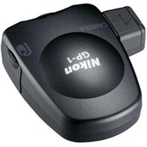
Nikon GP-1
Compatible
with GPS enabled Nikon Cameras, the Nikon GP-1 offers
a simple, no-frills solution to geotagging. A solid green LED light indicates when GPS coordinates
are locked, and blinks red when GPS is out of range. Correlation between
pictures and maps is supported by Nikon's ViewNX software and Nikon's
Picturetown online component.
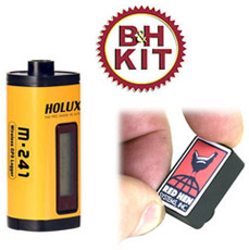
Red Hen Systems Blue2CAN Adapter with Holux
M-241 GPS Receiver
Together,
this unique bundle combines the best of tethered and untethered GPS data
gathering. The Holux M-241 GPS receiver (see review below) wirelessly transmits
GPS data to the Red Hen System's Blue2CAN Bluetooth adapter via enabling
top-notch GPS data gathering without the hassle of cables.
Compatible
with Nikon and Fujifilm digital SLRs with 10-pin remote sockets.
UNTETHERED GPS DEVICES
Untethered GPS units
collect GPS data without directly being connected to your camera. An untethered
unit is ideal for cameras which are not equipped with inputs required for tethered
data gathering. The premise is basically the same – carry the GPS device along
with you. The unit must be exposed so that it can collect data accurately
(attach the unit to your backpack or camera strap, for example). After a day of
taking photos, sync the GPS data on your computer with provided software, and
the raw GPS data will directly embed into your photo's metadata.
The following are
examples of untethered devices—
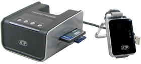
ATP Electronics GPS
Photo Finder Mini
ATP Electronic's GPS Photo Finder Mini syncs GPS data
without a PC. Simply carry the Photo Finder with you, pop the device and your
memory card into its docking station, and the GPS data will automatically sync
to the photos on your memory card. GPS Mapping is optimized for Google Earth,
Google Maps, panoramio, and locr. Compatible with SD, MMC,
MS, and CF cards.
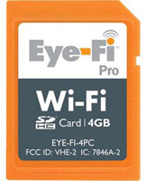
Eye-Fi 4GB Wi-Fi Pro
The Eye-Fi Pro comes in a handy, easy to use SD Card format.
Pop it into an SD card slot, and convert just about any camera into a
geotagging device. Latitude and longitude coordinates are triangulated from
Wi-Fi hotspot signals making it an ideal geotagging device in cities where
Wi-Fi signals are prevalent.
An 802.11 Wi-Fi is also built directly into the Eye-Fi card
for wireless photo transfer to your computer without the cables. Save time
without the cumbersome cables.
GiSTEQ DPL700 PhotoTrackr Lite Geo
Gisteq's PhotoTrackr
Lite's sleek and light design caters to travelers. One AA battery powers this
unit for 22+ hours of normal use. Coupled with Smart Trip Recording "auto
wake up" ensures that you focus more on taking photos without worrying about
the battery charge. Multiple format export (NMEA, GPX, KML,
and HTML) and multi-language support round out this adventurous GPS package.
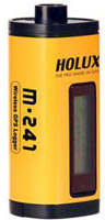
Holux M-241 GPS Datalogger with USB &
Bluetooth Connectivity
At first glance, the
Holux M-241 sports a small LCD display to monitor critical GPS data—position,
speed, memory size, date & time. Internal memory is capable of recording up
to an impressive 130,000 GPS positions, while 32 parallel satellite-searching
channels and a demodulator ensure fast, accurate data acquisition. A Bluetooth
and USB dual interface saves KML, NMEA, GPX or Binary files to your computer. Powered by AA batteries.
Jobo photoGPS Datalogger
The Jobo photoGPS
datalogger's claim to fame is its exhaustive GPS data gathering—city, street,
country, and closest point of interest, when coupled with supplied software.
Its shape lends itself to mounting on the hot shoe of a digital SLR. Wielding
its own USB-rechargeable internal battery effectively eliminates battery drain
from a host camera. A fully-charged unit "wakes up" only when a photo is taken,
and "sleeps" in between exposures.
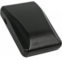
GiSTEQ PhotoTrackr Mini DPL900
The GiSTEQ PhotoTrackr Mini DPL900 is compatible with all digital cameras and embeds GPS data your picture files, including RAW files. The PhotoTrackr Mini DPL900, which includes Google Earth-compatible PhotoTrackr software, comes clad in a rather racy-looking black and yellow casing.
AROUND THE WORLD IN A DAY
Equipped with a Nikon D90 and tethered Nikon GP-1
GPS device, I set out to circumnavigate the World Showcase at EPCOT. It took me
exactly 1 hour and 38 minutes to travel through Mexico, Norway, China, Italy,
Germany, Japan, Morocco, United Kingdom, France, and Canada.
Shooting with the GP-1 was relatively easy. I just plugged
the device directly into the camera with supplied cables, mounted it into the
hot shoe, and I was ready to shoot. A solid green light indicates when a GPS
signal is locked and ready. Here are a few examples of photos with extracted
geotagging data from the trip.
 |
Mexico
Latitude N 28 22. 286'
Longitude 81 32 848'
Altitude 25m
Time 18:03:47 |
 |
Norway
Latitude N 28 22. 236'
Longitude 81 32 817'
Altitude 16m
Time 18:10:39 |
 |
France
Latitude N 28 22. 170'
Longitude 81 33 125'
Altitude 14m
Time 19:17:43 |
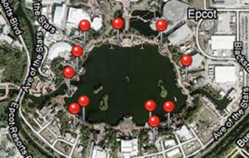
After I was done shooting, I simply uploaded the photos to
Apple's iPhoto. Using the GPS data from the shoot, iPhoto mapped out the whole
trip for me. From here, I can click on any of the red pins, and the photos
taken at that specific location are retrieved and categorized.
Furthermore, each individual photo's GPS data is mapped in
iPhoto. Click on any geotagged image and the time and specific
location is pinned on Google Maps for you.
WRAP UP
Hopefully our trip around the world gave you a quick
glimpse of the possibilities of GPS technology and its photographic
applications. A variety of accessories
are available to extend and complement the onboard capabilities of a GPS
device.
GPS devices are ideal for any photographer who wishes to
expand the capabilities of their photography to online applications or data
gathering. The simplicity and accessibility of simple GPS units let you geotag right out of the box. For the everyday photographer,
user friendly GPS technology offers yet another way to visually access and
share photos online. And for the specialist, advanced GPS tools enable
extensive data gathering capabilities for specific applications.
|