Autel Robotics EVO Max 4T Industrial Drone

BH #AUEMAX4TBND • MFR #102001823
Autel Robotics EVO Max 4T Industrial Drone
Key Features
  • Quad Camera with Thermal & Range Finding
  • 8-Camera 720° Obstacle Avoidance
  • Anti-Jamming & Anti-Interference
  • Drone-to-Drone Autonomous Communication
For critical industrial and first responder missions, the EVO Max 4T Industrial Drone from Autel is an ideal tool, providing a robust set of technologies for efficient handling of a wide variety of scenarios. The primary payload offers an 8K zoom, 4K low-light wide-angle, and thermal camera, along with a laser rangefinder. Together they make quick work of inspections, search and rescue, security overwatch, land surveying, and many other operations.
In Stock
$8,999.00
$750/mo. suggested payments for 12 Mos.
with the credit card.§ 
or Save the Tax with the credit card. 
WARNING: Carefully read instructions to ensure proper configuration before use. Failure to use this product responsibly may result in loss, damage, or injury.

Ask Our Experts
800.606.6969

Autel Robotics EVO Max Overview

  • 1Description
  • 2
  • 3
  • 4Eliminate Blind Spots
  • 5Mission-Ready Payload
  • 6Fly Without Restrictions
  • 7A Mind of Their Own
  • 8Eye in the Sky
  • 9Smart Controller & Skylink
  • 10Enhanced Live View
  • 11Autel Enterprise App
  • 12Data Security
  • 13Additional Features
By B&H Photo's
For critical industrial and first responder missions, the EVO Max 4T Industrial Drone from Autel is an ideal tool, providing a robust set of technologies for efficient handling of a wide variety of scenarios. The primary payload offers an 8K zoom, 4K low-light wide-angle, and thermal camera, along with a laser rangefinder. Together they make quick work of inspections, search and rescue, security overwatch, land surveying, and many other operations.

The drone itself can get to locations and perform tasks quickly, even in adverse conditions. Flown by a pilot with the included Smart Controller V3, or allowing the EVO Max 4T to take advantage of a host of advanced navigation and obstacle avoid technologies to fly semi or fully autonomously; alone or together as a fleet or swarm of drones.

Eliminate Blind Spots
With eight different cameras and 720° of coverage, the EVO Max 4T effectively eliminates blind spots when it comes to obstacle avoidance during flight. A combination of a binocular vision system and millimeter wave radar is used by the onboard Autel Autonomy Engine to perceive objects down to 0.5" in size and facilitate autonomous path finding, even in low-light and rainy conditions. You can also use the system to collect data on your environment to create 3D flight paths through mountains, forest, and buildings.
Mission-Ready Payload
Regardless of the challenge in front of you, the integrated 3-axis gimbal and payload of the EVO Max 4T can likely handle it. It features two RGB cameras, a thermal camera, and laser rangefinder.

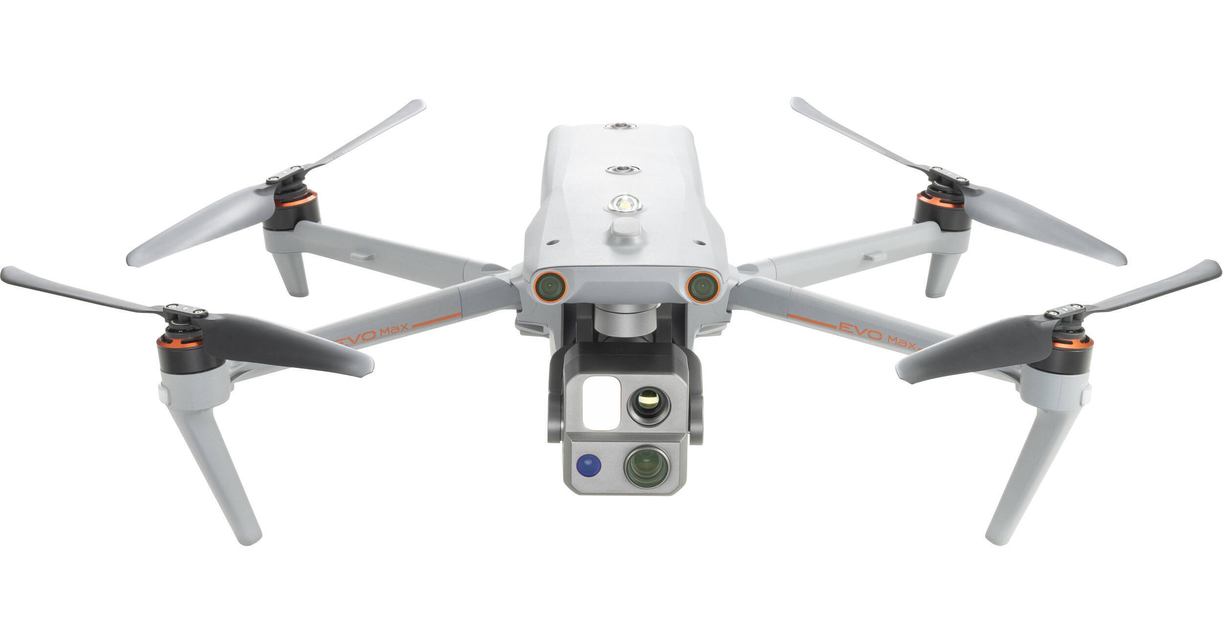
  • Zoom Camera: Up to 8K of resolution with 10x optical zoom and a hybrid 160x zoom that can display clear details on targets up to 1.24 miles away.
  • Wide-Angle Camera: 85° FOV with the ability to record up to 4K/30 video and low-light images with Moonlight Mode, which reduces noise and enhances HDR.
  • Thermal Camera: Ideal for rescues and inspection, you get 640 x 512 resolution footage at 30 fps with a 16x zoom and detection range from -4 to 1022° F.
  • Laser Rangefinder: Obtain coordinates and altitudes from 16.4' to 0.75 miles away with an approximate accuracy of 3.3'.
Fly Without Restrictions
Anti-jamming and anti-interference flight control modules and algorithms are integrated into the EVO Max 4T to counter RFI, EMI, and GPS spoofing. This helps you fly safely near dangerous and complex structures, such as power lines. You can also use this technology to let the drone fly in GPS-denied locations, such as within a hardened structure, in a tunnel, or underground.
A Mind of Their Own
With A-Mesh 1.0 mesh networking, the EVO Max 4T is capable of drone-to-drone autonomous communication, connection, and collaboration. Essentially, a fleet of EVO Max 4T drones can operate seamlessly as one unit. If one drone fails or exits the area, the system will independently self-organize and continue to relay information.

Each drone relays information by acting as relay points, which can dramatically increase BVLOS (Beyond Visual Line of Sight) operations. A single pilot can control the entire fleet, or a group of pilots can pilot simultaneously, with or without LTE coverage. To increase coverage, optional static communication nodes can be placed on hills or poles, or a swarm of drones can provide mobile communication points.

Eye in the Sky
Utilizing Autel's AI recognition technology, the EVO Max 4T is able to automatically identify and lock onto different target types, such as heat sources, moving people, or vehicles. Once locked on, the drone can perform high-altitude tracking and data collection.
Smart Controller & Skylink
When piloting the EVO Max 4T, the 3rd generation of Autel Skylink works in tandem with the 3rd generation Smart Controller V3. Skylink 3.0 gets your commands to the drone and the drone's footage back quickly, efficiently, securely, and from long distances. The 6 built-in antennas can transmit 1080p/60 real-time video back to the Smart Controller from up to 12.4 miles away with under 150 ms of latency. The signal is kept stable with quad-band support (900 MHz, 2.4 GHz, 5.2 GHz, and 5.8 GHz), and offers optional 4G cellular integration. That critical data is secured along its journey with robust AES-256 data encryption.

Pilots receive that drone footage and essential telemetry in real-time on the huge, built-in 7.9" display (2048 x 1536 resolution), with daytime viewing support thanks to 2000 nits of brightness. Footage can be transferred off to mobile devices quickly via SuperDownload at a rate of 20 MB/s for immediate review and analysis. With 128GB of integrated storage, you can keep footage on the remote, along with 3rd party apps. Other members of the team can monitor the action if needed via the HDMI port and an optional external display, and pilots can utilize all of this for up to 4.5 hours at a full charge.

Enhanced Live View
  • Multi-Channel Projection Screen: Supports simultaneous output of RGB video, infrared, night vision, and wide-angle images. Please note that as of this writing, this feature is planned as a future update.
  • AR Scene: Geo-location data and other aircraft location information detected by ADS-B can overlay on a real-time map, which conveniently confirms the drone's location and helps avoid airborne risks. Please note that as of this writing, this feature is planned as a future update.
Autel Enterprise App
Built for industrial and professional applications, the updated interface provides easy and intuitive operation and offers a host of autonomous and semi-autonomous mission planning functions.

  • 3D Map Planning: Plan, create, and execute 3D waypoint mission plans on a 3D map.
  • Quick Mission: Temporary quick missions can be created while executing other missions, and multiple sub-missions can be stacked for enhanced flexibility.
  • Mission Reproduction: When activated, you can fly a manual or semi-autonomous mission, or string multiple missions together. The drone will automatically record the camera angles and can replicate the mission you flew.
  • Polygon Mission: Supports one-click automatic generation of polygon flight areas.
  • Terrain Follow: Maintain relatively constant altitude from the ground for uneven or sloped terrain.
  • Rectangular Mission: Supports one-click automatic generation of a rectangular flight area.
  • Waypoint Mission: Add waypoints for flexible and non-structured flight paths.
  • Oblique Photography: Automatically plan 5 groups of routes (1 Ortho and 4 Oblique) according to the flight area set by the user.
  • Spiral Mission: Helical flight search in a designed area for SAR.
  • Vertical Scan: Perform vertical surveys for building facades, open pit walls, and towers.
  • Corridor Mission: Fly missions for roads, rivers, pipelines, power lines, and other narrow, large-scale terrain.
  • Automatic Mission Generation & Data Capture: Automatically produce routes by adding regional boundary points through dots or importing KML files.
Data Security
The video, images, and flight logs are all secured with AES-256 data encryption and password protection. In addition, all user and aircraft data, including flight logs, locations, and account information, can only be accessed physically by those with access to the aircraft.
Additional Features
  • Designed to deploy to the sky in just 15 seconds
  • IP43-rated water and dust resistance
  • Up to 42 minutes of flight
  • Hot-swappable batteries
  • Up to 52 mph flight speed
  • Up to 27 mph wind resistance
  • Up to 23,000' service ceiling
  • Foldable design for easy storage and transport

Autel Robotics EVO Max Specs

Key Specs
Maximum Horizontal Speed
51.4 mph / 23 m/s
Maximum Flight Time
42 Minutes
Rotor Configuration
4
Image Sensor
1/2"-Type CMOS
Internal Recording Modes
7680 x 4320
Still Image Support
JPEG
(8000 x 6000)
Vision System
Downward / Upward / Forward / Backward / Left / Right
Control Method
Included Transmitter
Maximum Operating Distance
12.4 Miles / 20 km
Mobile App Compatible
No
*As of February, 2023: Check with manufacturer for the most up-to-date compatibility
Weight
3.6 lb / 1620 g (WithBattery, Gimbal)
4.4 lb / 1999 g Maximum for Takeoff
Performance
Maximum Horizontal Speed
51.4 mph / 23 m/s
Maximum Ascent Speed
17.9 mph / 8 m/s
Maximum Descent Speed
13.4 mph / 6 m/s
Maximum Wind Resistance
27 mph / 12.1 m/s
Flight Ceiling
4.3 Miles / 7000 m
Maximum Flight Time
42 Minutes
Maximum Hover Time
38 Minutes
Maximum Tilt Angle
35°
Hovering Accuracy
Vision Positioning
Vertical: ±0.3' / 0.1 m
Horizontal: ±0.49' / 0.15 m
GNSS
Vertical: ±1.0' / 0.3 m
Horizontal: ±1.0' / 0.3 m
RTK
Vertical: ±0.49' / 0.15 m
Horizontal: ±0.3' / 0.1 m
Maximum Angular Velocity
300°/s (Pitch)
120°/s (Yaw)
Rotor Configuration
4
USB
1 x USB-C (Service Only)
Media/Memory Card Slot
Single Slot: SD/SDHC/SDXC
Operating Temperature
-4 to 122°F / -20 to 50°C
Camera
Image Sensor
1/2"-Type CMOS
Sensor Resolution
Effective: 48 Megapixel (8000 x 6000)
Focal Length
11.8 to 43.3mm / 64 to 234mm (35mm Equivalent)
Maximum Aperture
f/2.8
Minimum Aperture
f/4.8
Minimum Focus Distance
16.4' / 5 m
ISO Sensitivity Range
Photo/Video
100 to 6400 in Auto Mode
Photo
100 to 12,800 in Manual Mode
Video
100 to 6400 in Manual Mode
Shutter Speed
1/8000 to 8 Second
Internal Recording Modes
7680 x 4320
Broadcast Resolution
No
Still Image Support
JPEG
(8000 x 6000)
Gimbal
Number of Axes
3-Axis (Pitch (Tilt), Roll, Yaw (Pan))
Rotation Range
Controllable Range
Pitch (Tilt): 120° (-90 to 30°) 
Mechanical Range
Yaw (Pan): 180° (-135 to 45°) 
Roll: 90° (-45 to 45°) 
Pitch (Tilt): 90° (-45 to 45°) 
Follow Speed
Tilt: 200°/s
Stabilization Accuracy
±0.005°
Vision/Sensing System
Vision System
Downward / Upward / Forward / Backward / Left / Right
Vision System Capabilities
Forward
Measurement Range: 0.7 to 164.0' / 0.2 to 50 m
Field of View: 60° (Horizontal) / 80° (Vertical)
Backward
Measurement Range: 0.7 to 164.0' / 0.2 to 50 m
Field of View: 60° (Horizontal) / 80° (Vertical)
Lateral
Measurement Range: 0.7 to 164.0' / 0.2 to 50 m
Field of View: 60° (Horizontal) / 80° (Vertical)
Upward
Measurement Range: 0.7 to 164.0' / 0.2 to 50 m
Field of View: 360° (Horizontal) / 190° (Vertical)
Downward
Measurement Range: 0.7 to 164.0' / 0.2 to 50 m
Field of View: 360° (Horizontal) / 190° (Vertical)
Remote Controller / Transmitter
Control Method
Included Transmitter
Operating Frequency
0.9 GHz
2.4 GHz
5.8 GHz
Maximum Operating Distance
12.4 Miles / 20 km
Transmitter Power
2.4 G: 28 dBm (FCC), 20 dBm (CE, MIC, SRRC)
5.8 G: 27 dBm (FCC, SRRC), 14 dBm (CE)
0.9 G: 28 dBm (FCC)
Transmitter I/O
1 x HDMI
1 x USB-C
1 x USB-A
Battery Chemistry
Lithium-Ion
Battery Capacity
5800 mAh
Wi-Fi
Wi-Fi 5 (802.11ac) with MU-MIMO Support (2 x 2)
Bluetooth
No
Mobile App Compatible
No
*As of February, 2023: Check with manufacturer for the most up-to-date compatibility
Built-In Display Size / Type
7.9"  LCD
Display Resolution
2048 x 1536
Display Brightness
2000 nits / cd/m2
Operating Temperature
-4 to 104°F / -20 to 40°C
Flight Battery
Battery Chemistry
Lithium-Ion Polymer (LiPo)
Battery Capacity
8070 mAh / 120 Wh
Battery Configuration
4 S / 14.88 V
Charging Temperature
41 to 113°F / 5 to 45°C
Weight
1.1 lb / 520 g
General
GNSS Support
GPS, GLONASS, BeiDou, Galileo
Diagonal Size
1.5' / 464 mm
Overall Dimensions
22.7 x 5.9 x 26.0" / 576.0 x 149.0 x 660.0 mm (Folded)
10.1 x 5.2 x 5.4" / 257.0 x 133.0 x 136.0 mm (Unfolded)
Weight
3.6 lb / 1620 g (WithBattery, Gimbal)
4.4 lb / 1999 g Maximum for Takeoff
Packaging Info
Package Weight
20.25 lb
Box Dimensions (LxWxH)
19.9 x 16.3 x 9.7"

Autel Robotics EVO Max Reviews

See any errors on this page? Let us know

Does it have Dynamic RTH?

Does it have Dynamic RTH?
Asked by: Robert
Although the specification is not currently listed on the Autel Robotics EVO Max 4T Industrial Drone, it is expected upon release to offer a dynamic return to home like the previous Autel drones by selecting the Go Home button for the current home point position.
Answered by: Richard
Date published: 2023-04-17

Does it satisfy the made in USA criteria?

Does it satisfy the made in USA criteria?
Asked by: Matthew
The Autel Robotics EVO Max 4T Industrial Drone is made in China.
Answered by: Whitney H
Date published: 2023-05-08

Can it land on a moving base station?

Can it land on a moving base station?
Asked by: Robert
At the moment, the current specifications for the Autel Robotics EVO Max 4T Industrial Drone do not list dynamic return-to-home functionality. Manual landing is possible. See the link below: https://bit.ly/3YSA7nc
Answered by: Richard
Date published: 2023-03-14

How long does it take to charge the included ...

How long does it take to charge the included battery with the included charger?
Asked by: Kendall County Sheriff
  • y_2023, m_12, d_7, h_8CST
  • bvseo_bulk, prod_bvqa, vn_bulk_3.0.37
  • cp_1, bvpage1
  • co_hasquestionsanswers, tq_4
  • loc_en_US, sid_1749143, prod, sort_[SortEntry(order=HAS_STAFF_ANSWERS, direction=DESCENDING)]
  • clientName_bhphotovideo