GPS satellites have been freely accessible to the world through the "public good" policy of the United States Air Force and their NAVSTAR Global Position System (GPS). It is a system of satellites that broadcast a specific radio signal to connect to a receiver like this one. If three or more of the NAVSTAR satellites are in transmission range of the GPS unit; through simple mathematical calculations based on the distances between each orbiting satellite and the receiver, a 3-dimensional position on the X/Y/Z axes is determined. This in turn translates into latitude, longitude and altitude co-ordinates on a GPS receiver. These positions are then represented graphically with points and lines on a GPS unit's screen.
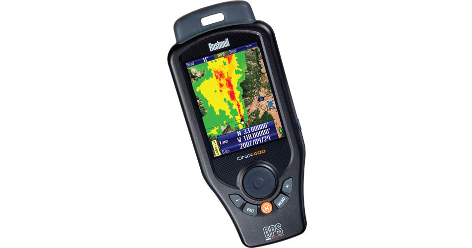
The Bushnell ONIX400 takes this technology one step further. Whereas all other dedicated GPS units rely on vector based graphics to display maps, trails and waypoints, the ONIX400 possesses the ability to rasterize a georeferenced satellite or aerial image on its large, vivid 3.5" screen. This results in a "real life" view of the area being navigated that can be layered over a vector-based map, letting you switch from one view to another with a push of a button. The ability to reference a true image of a route and its associated visual landmarks greatly simplifies and enhances navigation by GPS.
For those with XM Satellite radio subscriptions, the ONIX400 boasts an onboard XM receiver that gives users access to over 170 channels of radio programming as well as weather data no matter where they are located. Current and future climate information is displayed with the assistance of the NEXRAD Doppler radar weather system via the US National Weather Service.
Furthermore, the ONIX400 has a range of features that allow users to use its advanced functionalities in demanding conditions. Rubberized armor protects the receiver from damage and seals it to meet the IPX7 waterproof rating. Internally, there is a 128MB microSD card to store waypoints, tracks, and other navigational aids. As far as maneuvering is concerned, there is a built-in digital compass that is augmented by a barometer and altimeter to provide at-a-glance comprehensive geospatial and navigational data.
For multi-day treks or where full-time GPS tracking may be required, the ONIX400 has a battery-saving mode called SafeTrack, that dims the LCD display without turning the radio receiver off. This way power drain is minimized and the length of operation is extended. Standard AA Alkaline, Lithium, or NiMH rechargeable batteries are compatible with the ONIX400 and are replaceable in the field at any time.
The ONIX400 is identical to the ONIX350 with the addition of a built-in XM satellite radio receiver.